|
Größe: 9168
Kommentar:
|
Größe: 9543
Kommentar:
|
| Gelöschter Text ist auf diese Art markiert. | Hinzugefügter Text ist auf diese Art markiert. |
| Zeile 1: | Zeile 1: |
| ||<tablewidth="450px" tablestyle="TEXT-ALIGN: center"bgcolor="#ffffa0"> {{http://mikrocontroller.cco-ev.de/images/deu.gif}} Seite in [[MKGPS|deutsch]] ||<bgcolor="#ffffa0"> {{http://mikrocontroller.cco-ev.de/images/fra.gif}} page en [[fr/MKGPS|francais]] || See also: [[en/NaviCtrl|NaviCtrl]], [[en/MK3Mag|MK3Mag]] <<TableOfContents>> <<BR>> |
{{{#!wiki MK_Nav ||<class="MK_Nav_Header">[[en/MK-Board|MikroKopter-Boards]]|| ||<class="MK_Nav_Header">'''MK-GPS'''|| |
| Zeile 4: | Zeile 5: |
| {{http://gallery.mikrokopter.de/main.php?g2_view=core.DownloadItem&g2_itemId=84553&g2_serialNumber=1}} | }}} {{{#!wiki MK_select1 * {{http://mikrokopter.de/images/deu.gif}} [[MKGPS|deutsch]] * {{http://mikrokopter.de/images/fra.gif}} [[fr/MKGPS|français]] }}} <<BR>> See also: [[en/NaviCtrl|NaviCtrl]], [[en/MK3Mag|MK3Mag]] <<BR>> <<TableOfContents>> <<BR>> ||<class="MK_TableNoBorder":>{{http://gallery.mikrokopter.de/main.php?g2_view=core.DownloadItem&g2_itemId=94234&g2_serialNumber=2}}||<class="MK_TableNoBorder":width="5%">||<class="MK_TableNoBorder":>{{http://gallery.mikrokopter.de/main.php?g2_view=core.DownloadItem&g2_itemId=94239&g2_serialNumber=2}}|| ||<class="MK_TableNoBorder":>MKGPS V1.1||<class="MK_TableNoBorder":width="5%">||<class="MK_TableNoBorder":>MKGPS V2.1|| |
| Zeile 146: | Zeile 163: |
| KategorieHardware KategorieEnglish | [[KategorieMK-Baugruppe/en]] |
MK-GPS |
Inhaltsverzeichnis
MKGPS V1.1 |
MKGPS V2.1 |
MkGPS
The MKGPS is a GPS-receiver for the Mikrokopter.
Together with the NaviControl the following features are possible:
- autonomous position hold (Position-Hold or just PH)
- fly bach to start point (Coming Home or just CH)
Fly 3D-Waypoints (Waypoints)
- Logging the flight onto the SD-Card
showing the actual position and speed on the 'OSD'-screen in the KopterTool
showing the actual distance and speed on the JetiBox
Pointing the camera to a specific point: PointOfInterest
MKGPS Version 1.0
- the antenna has to be sticked onto the PCB and the conection pin needs to be soldered (only the one pin)
- set the solderjumper to (Passiv)
- the LED on top of the module starts lighting after power-up and starts flashing when GPS signal is good
MKGPS Version 2.1
- New Chipset: LEA-6S
- The Antenna is already mounted and soldered in the MKGPS2.1
- the USB-connector is not used and not assembled
- the solderjumper is already set to 'Passive'
the MKGPS 2.1 can be used on NaviControl 1.x and 2.0 since software Version 0.22
LEDs
- the green LED on the bottom side starts lighting after powrt up and light all the time
The LED on the top-side only lights after the module was initialized from the NC (since NC-Software 0.22)
- the LED on the top-side starts flashing when GPS signal is good
Installation
The Antenna needs to points upwards. There is a small arrow in one of the corners. Please point this towards Motor#1 (front). Install the included cable between MKGPS and NaviCtrl.
![]() The connecting plug towards NaviCtrl should be inserted into socket NAV (Can be seen in the above picture next to the ublox module). Whilst insertion into the USB socket does not cause any damage, there would be no transfer of GPS data towards the NaviCtrl!
The connecting plug towards NaviCtrl should be inserted into socket NAV (Can be seen in the above picture next to the ublox module). Whilst insertion into the USB socket does not cause any damage, there would be no transfer of GPS data towards the NaviCtrl!
- The black area around the antenna patch is also needed for GPS reception and must remain free.
- A plastic cover must not directly touch the GPS patch.
Initial Functionality tests
connect NaviCtrl via MKUSB to the PC
with on the MikroKopter
Open the KopterTool - klick onto 'MKGPS'. The parameter GPS-Data Counter should be continually increasing – this indicates that the GPS is correctly connected and data is being correctly read.
Only MKGPS Version 2.x: after swithing on the MikroKopter the NC initalizes the GPS-Module (after 3-5 second). If the top-LED goes on, the communication to the module is good.
GPS Fix
A GPS Fix is indicated by a flashing LED on the MKGPS.
During the first start-up, the NaviCtrl will build a complete Almanac/Index. This contains satellite positions and paths. A complete cycle to build this Almanac takes 12.5 minutes.
Based on the last known position the fix will from then on be built up much quicker.
If the fix takes a longer time, it could be that the small battery on the GPS board is too weak. The battery is normally charged to about 3V. The battery is always charged when the GPS module is in operation. If the battery voltage is significantly lower than 3.0 V, it can be charged by providing power to the GPS module. One way is through the Naviboard's USB port (with the MKGPS connected). The ribbon cable to the FC should be removed. Another method is to power the MKGPS with 5V on one of the "5V-Pads" on the edge and 0V on ground (GND). Charging takes about 24 hours.
The purpose of the battery is to keep the ephemerides in RAM and the realtime clock running after power off to shorten the re-aquire time.
Information: GPS_Compendium(GPS-X-02007).pdf
Improvement of the signal strenght by using the GPS-Shield
http://gallery.mikrokopter.de/main.php/v/tech/GPS_Shield1.jpg.html
This is an enlargement of the ground-plane of the GPS-Receiver to increase the signal strenght. Also it shields the antenna against electro magnetic fields of the other electronics.
See also: GPS-Shield
Show the MK-GPS Data
Start KopterTool and swith to MKGPS (connect the MKUSB to the NC)
Now you see GPS-data and signal strenth
![]() Warning: to not do this during flight - the navigation will stop then.
Warning: to not do this during flight - the navigation will stop then.
Schematic
Configuration
Since Navi-Ctrl software version 0.22a the MKGPS is auto-configured during the startup phase.
A manual configuration is not necessary and also not recomended.
![]() the MKGPS 2.1 has a ROM-based LEA-6S chipset. The configuration will be lost after power down
the MKGPS 2.1 has a ROM-based LEA-6S chipset. The configuration will be lost after power down
The following information for the manual configuration of the MKGPS is only for experts.
![]() Warning: A misconfiguration can cause a lock out and an access to the MKGPS is not possible anymore. The auto configuration feature will fail also in this case.
Warning: A misconfiguration can cause a lock out and an access to the MKGPS is not possible anymore. The auto configuration feature will fail also in this case.
To disable the auto-configuration feature the Navi-Ctrl needs a MicroSD-Card in the slot. After startup the software creates a configuration file named SETTINGS.INI on the card. Removing the card from the slot and opening the file with a text editor on the PC the SETTINGS.INI can be modified. The entry GPSAUTOCONFIG = 1 must be changed to GPSAUTOCONFIG = 0 and the card has to be put back into the slot at the Navi-Ctrl permanently.
Download
The gps configuration software can be downloded here U-Blox-Center. The uBlox config file is transferred into the LEA-4H via USB or serial port.
Settings Store/Re-store (only for Experts)
Ublox Datacenter
The KopterTool has a feature to make a transparent communication for the uBlox-Tool
Simply hold the 'ALT'-Button when klicking onto 'EXIT'
Close the KopterTool and open the Ublox-Tool. select the COM-Port (same as the MKUSB) and change the baudrate to 57600Bd.
Now the behavior of the NaviCtrl is transparent to us. Launch the U-blox Datacenter and open the serial port:
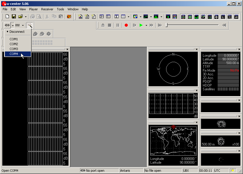
- . Select GPS Configuration:
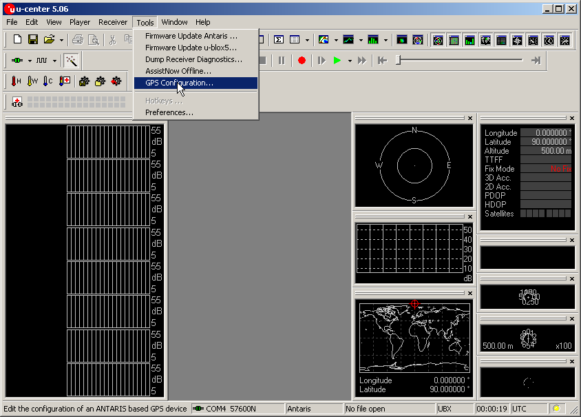
- . Load the configuration file:
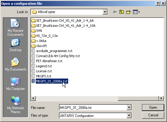
- . Select the Store configuration checkbox.
Click File >> GPS:
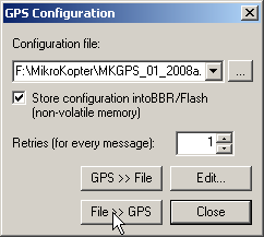
- . Configuration is flashed into the MKGPS:
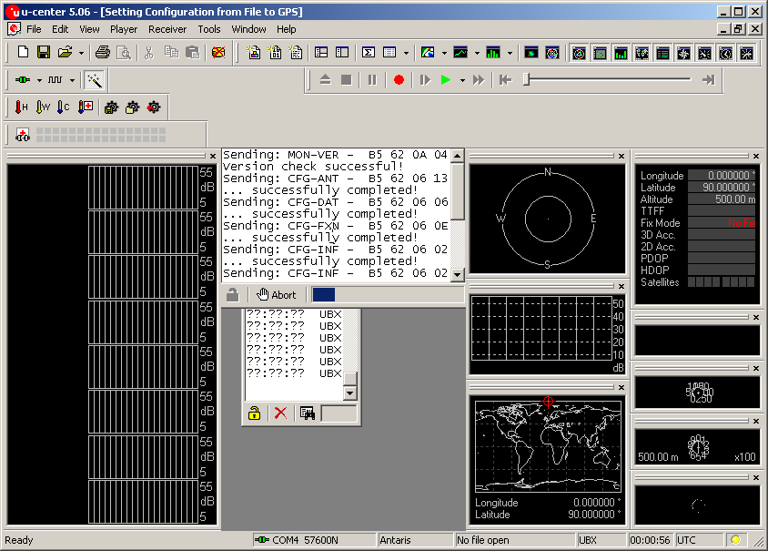
 ToDo: more to be done here
+++++++++++++++++++++++++++++++++++++++++++++++++++++++++++++++++++++++++++++++++++++++++++++++++++++++++++++++++


