Firmware-2.14 |
Inhaltsverzeichnis
Firmware-2.14
Release date: 16 Feb. 2016
License: LICENSE.TXT
Links:
Public Beta 2.13: Forum
Older Version 2.12 from October 2015
List of all versions here: KategorieFirmware
Download
FlightControl V2.14c für schwarze FC (FC2.1 - 2.5) (MEGA1284)
 The old FlightControls until V2.0 (with ATMEGA644 Processor) are only supported until 2.12 - the code is too huge since V2.14
How to update?
How to update: SoftwareUpdate
FlightControl V3.0
Since this version, the new FlightControl V3.0 is supported.
FlightControl with integrated NaviControl

- Proven technology with additional features
Compatible with FlightControl and NaviControl Software
Connecting a trigger input (hot shoe contact) -> camera trigger positions are logged in a separate logfile
Three separate I2C buses -> BL-controller, Compass, camera control etc.
- Free serial port, for example, to connect to RTK GPS systems (by later software updates)
Three analog inputs -> the values are recorded in the log file
Connection for CAMCtrl -> interface for SONY cameras incl Zoom and feedback to the transmitter (REC, counters for photos, etc.)
- Redundant serial data bus to the BL-V3 controllers (even with a single FC)
- CAN bus: for connecting a redundant flight control or other modules
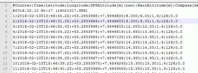
Logfile for camera trigger positions
FlightControl V3.0 has a seperate input for a hot shoe contact of a camera

In the GPX-folder of the SD-Card, you will find a seperate logfile for the camera trigger positions.

The advantage is, that the FC now nows exactly the time of the photo release and can add the correct coordinate.
Status display of the redundant slave
If two FC V3.0 are connected in a Master/Slave system, the status can shown:

Maps in the KopterTool

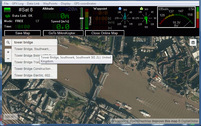
The KopterTool can now show map data from the Internet directly.
- So you can select the appropriate map section and save the map.
- The stored map is then used for the Waypoint navigation. This ensures a stable offline mode, if the Internet connection is disturbed.
- The Map file name is now also stored in the WPL file (Waypoint list), so that the card can be loaded automatically with the WPL.
Note:
- On the PC must be at least Internet Explorer 9 installed (which is installed automatically in the newer versions of Windows)
- Maybe a unique start as administrator is required (you'll get a notice)
Background:
There is a registry entry created automatically, so that the MK-Tool can use the correct version of Internet Explorer, otherwise the IE would run in compatibility mode
(Who wants to know more, Ask Google: "FEATURE_BROWSER_EMULATION" ...)
No-Fly Zones as Overlay
Now you can display some known fight destriction zones.
The MikroKopter tool airspaces and Restricted Zones are only for verification.
Furthermore, only zones are displayed that start at grond level. Zones in higher flight level are not visible.
Please always check against current ICAO charts.
No responsibility for the accuracy or completeness of the data. Use at your own risk.
Source: http://www.openaip.net Some airport oder helipad is missing, just register on their site and add the data...
Other changes
Settings
The new settings are designed so that in future versions (newer than V2.14) the settings are not automatically deleted.
Waypoint-Generator
Now arcs are possible

rising on the first Waypoint
The MK rises first, before flying to the first Waypoint
Waypoints above 20m -> the MK rises until 20m and then starts flying to the point
aypoints below 20m -> the MK rises to the according altitude and then starts flying to the point
SONY CamCtrl
Since this version, the CamCtrl for SONY cameras is supported.

It is an improved LANC-Interface which supports the new SONY Multi protocol. So, it supports the Sony Alpha series like a5000/a6000 or the DSLR
The new CamCtrl will be connected to the I2C-Bus Molex Connector of a NaviControl.
Features:
- Start/Stopp Video
- Trigger Photos
- Zoom
- switch on the camera automatically
- avoid Sleep-mode of the camera
- PAL Output (only the camcorders with LANC have PAL)
- external Status LED can be connected
Status display
The CamCtrl shows the status of the camera and shows it in the HoTT/Jeti/KopterTool telemetry
You can see in the transmitter display:
- REC
- Zoom active
- camera took xxx pictures
- Camera is on or off (battery empty)
- Cable to camera loose
For example


-> "R" Means: REC (Video recording)
-> "4" (number) menans -> x photos taken
Reminder: Start and Stopp of the motors
![]() Since Version 2.00 you must push both sticks into the corner.
Since Version 2.00 you must push both sticks into the corner.
Bugfixes
FC 2.14c (19.04.2016)
checking baro-sensor during flight. Report "ERR:Pressure sensor" and disable Altitude control in case of a Problem
NC2.14b (29.02.2016)
- comment in the triggerlog: Longitude and Latitude mixed
- bugfix: external compass was not detected correctly on NC2.x
NC 2.14d (31.03.2017)
- Bugfix (only redundant setups): When using one MKGPS V3.5 on two redundant NCs, it could happen that the configuration of the GPS failed and the NC reported "GPS-Error" after startup.
NC 2.14e (19.04.2016)
- disable altitude limitation if the barosensor has a failure
- KategorieFirmware/FC


