This page as an PDF-Document? Click on that Symbol and wait a little moment... ---> |
MikroKopter Map-Tool |

Inhaltsverzeichnis
MikroKopter Map-Tool
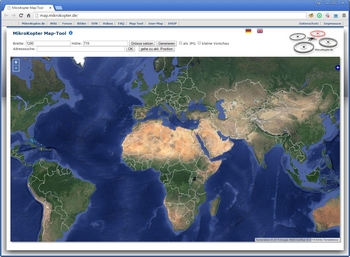
With our MikroKopter Map-Tool you can create very easy maps for your waypoint navigation.
Each saved map is already georeferenced. The coordinates of the vertices will be saved with the map.
The map view can be saved with a single image or a zoom level.
Open the Map-Generator
You can open the MikroKopter Map-Tool:
with this link: MikroKopter Map-Tool
or directly with the KopterTool OSD.
Use
Card size
If you open the MikroKopter MAP-Tool with the KopterTool OSD, the coordinates of the MikroKopter (if connected) and the size of the OSD map window (Link) will be submitted to the program.
But you can also manually enter the desired card size (width / height) and press the button set size.
View
Search address
If you will search the location,insert the name under search and press the button OK.

Current position
A click on Go to current pos. will open the current position of your Copter.
(only if the copter is connected and has a !Satfix)
Save map
As a single JPG image
The displayed map can be stored as a single .jpg image. For this select as JPG
and press the button generate. The image is then saved on your computer. The file name
consists of the name "mkmapgen" and the current date. Example: mkmapgen.2015_07_22.jpg
As MKZ file with zoom
If you only press generate (without as JPG) you will get a MKZ File. With this file you
can zoom the picture in 2 steps in the KopterTool OSD. The MKZ file consists of the name "mkmapgen" and
the current date. Example: mkmapgen.2015_07_22.mkz
Info:
The MKZ file is a zipped file which can be opened with any unzipper.
The file contains an image of the displayed view (mkmapgen.jpg), and an image with
a zoom level less (mkmapgen1.jpg).
You can switch between the zoom levels in KopterTool OSD by using the +/- button:


